

Navigating the 363 miles of the Oregon Coast requires a departure from the typical American road trip mindset. Unlike the linear, high-speed travel found on inland interstates, the Pacific Coast Scenic Byway (Highway 101) demands a slower, more observational pace. This stretch of public land is defined by dramatic basalt cliffs, temperate rainforests, and a unique legal status that ensures the entire shoreline remains open to the public. Unlike the manicured beaches of Southern California or the private estates of the Eastern Seaboard, this region is characterized by its rugged, often unpredictable environment. For the traveler, the challenge lies in the sheer diversity of the geography. The northern reaches offer high-density tourism and historical depth, while the southern corridor provides isolation and some of the most complex geological formations in North America. Navigating this coastline effectively requires an understanding of the distinct micro-climates and the logistical constraints of Highway 101, where a 50-mile drive can easily take two hours due to winding turns and scenic elevation changes.
Mapping the Three Distinct Coastal Jurisdictions
To determine the best places to visit on the Oregon Coast, one must first categorize the coastline into its three primary segments. Each region serves a specific type of traveler based on infrastructure, accessibility, and natural features. The North Coast, stretching from Astoria to Tillamook, is the most frequented due to its proximity to Portland. It is characterized by wide, sandy beaches and significant historical landmarks. The Central Coast, running from Lincoln City to Florence, offers a blend of marine science centers and massive sand dunes. Finally, the South Coast, from Coos Bay to Brookings, is the most remote and geologically striking, often referred to as the “Wild Coast.” Choosing between these regions depends largely on whether you prioritize high-end amenities and culinary variety or the raw, unbridled power of nature in a secluded setting.
The North Coast: Accessibility and Cultural Density
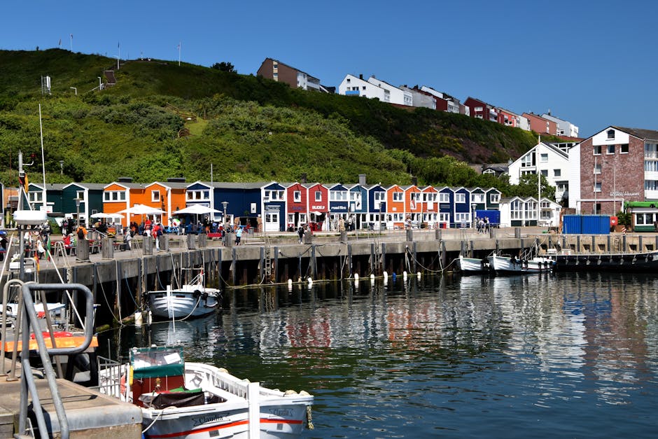
The North Coast is the logical starting point for those arriving via Portland International Airport. Astoria, situated at the mouth of the Columbia River, serves as a cultural anchor. It is less of a beach town and more of a maritime hub, featuring Victorian architecture and a burgeoning culinary scene. Visitors often climb the 164 steps of the Astoria Column for a panoramic view of the Youngs Bay and the surrounding mountains. However, for those seeking the quintessential “Oregon beach” experience, Cannon Beach is the primary destination. The trade-off here is density. During peak summer months, the population of Cannon Beach swells significantly, leading to parking shortages and increased wait times at local establishments. For travelers who prioritize convenience, high-end dining, and proximity to major transport hubs, the North Coast is the superior choice, despite the inevitable crowds that gather around Haystack Rock.
The Central Coast: Marine Science and Family Infrastructure
Moving south into the Central Coast, the landscape shifts from the wide, sandy stretches of the north to a more varied terrain of rocky headlands and massive dunes. Newport acts as the regional center, housing the Oregon Coast Aquarium and the Hatfield Marine Science Center, making it the premier destination for education-focused travel. This area is particularly suited for travelers interested in marine biology and family-oriented activities. The infrastructure here is robust, with a wide variety of mid-range accommodations and accessible fishing piers. Further south, the Oregon Dunes National Recreation Area begins near Florence. This 40-mile stretch of shifting sands, some reaching heights of 500 feet, provides a stark contrast to the rocky headlands. It is the best region for those interested in off-road vehicle recreation, sandboarding, or unique coastal hiking through dune-forest transitions where the sand meets the Sitka spruce forests.
The South Coast: Rugged Isolation and Geological Wonders
The South Coast is often overlooked due to the driving distance from major metropolitan areas, yet it contains the most spectacular scenery in the state. The Samuel H. Boardman State Scenic Corridor is the highlight of this region, offering a landscape that feels more like the Scottish Highlands than the American West. Here, the basalt sea stacks are more numerous and the cliffs more precipitous. The climate in the south is also slightly milder, often referred to as the “Banana Belt” of Oregon, particularly around Brookings, where temperatures can remain 10 degrees warmer than the northern beaches. This region is ideal for the experienced hiker or photographer who values solitude over amenities. Service infrastructure is thinner here; travelers must plan fuel and food stops with more precision, as it is not uncommon to go 30 miles without seeing a gas station or a grocery store.
| Region | Primary Draw | Best For | Crowd Level | Average Temp (Summer) |
|---|---|---|---|---|
| North Coast | Astoria, Cannon Beach | Dining, History, Proximity to PDX | High | 64°F |
| Central Coast | Newport, Oregon Dunes | Families, Science, ATVs | Moderate | 66°F |
| South Coast | Samuel H. Boardman, Brookings | Photography, Hiking, Solitude | Low | 70°F |
Topographic Highlights: From Haystack Rock to the Southern Arches
When identifying the specific best places to visit on the Oregon Coast, the selection must be based on ecological significance and visual impact. While many towns offer charming boardwalks, the true value of the Oregon Coast lies in its state parks and protected scenic areas. These locations provide the most direct access to the region’s unique basalt formations and diverse wildlife, including gray whales, harbor seals, and tufted puffins. The geology of the coast is a record of ancient volcanic activity, where massive lava flows from the interior of the continent met the Pacific Ocean, cooling into the hard basalt structures that resist erosion today.
Cannon Beach and Ecola State Park
Cannon Beach is home to Haystack Rock, a 235-foot sea stack that serves as a vital nesting ground for seabirds. While the beach itself is world-renowned, the adjacent Ecola State Park offers a more comprehensive view of the coastline. The park features the Indian Beach trail, which provides vantage points of the Tillamook Rock Lighthouse—a decommissioned structure built on a basalt islet nearly a mile offshore. The geological history here is visible in the layered sedimentary rock and the massive basalt flows that originated in Eastern Oregon millions of years ago. For the best experience, visit during low tide to explore the tide pools at the base of Haystack Rock, but remain cognizant of the strict federal protections regarding the nesting areas. The Haystack Rock Awareness Program often has volunteers on-site with spotting scopes to help visitors identify the rare tufted puffins that nest there from April through July.
Cape Perpetua Scenic Area and Thor’s Well
Located just south of Yachats, Cape Perpetua is the highest point on the Oregon Coast accessible by car. The viewpoint sits 800 feet above sea level, offering a panoramic perspective of the Pacific. However, the most significant draw is the Cook’s Chasm area, which contains Thor’s Well—a “drainpipe” in the rocky shelf that appears to swallow the sea. This is a collapsed sea cave that creates a spectacular fountain effect during high tide or stormy weather. Nearby, the Spouting Horn and the Devil’s Churn demonstrate the violent energy of the ocean as it is forced through narrow basalt fissures. Safety is a critical consideration here; the basalt shelf is extremely sharp and unpredictable surges can be dangerous. Researchers and photographers suggest arriving one hour before high tide to capture the most dramatic water movement while maintaining a safe distance from the edge. Never turn your back on the ocean in this area, as “sneaker waves” are a frequent and documented hazard.
Samuel H. Boardman State Scenic Corridor
This 12-mile corridor north of Brookings is arguably the most beautiful section of the entire Pacific coastline. It contains the Natural Bridges—a series of arched rock formations that have been carved by wave action over millennia. The trails here are steep and often muddy, requiring proper footwear and a degree of physical fitness. Unlike the wide beaches of the north, the coves here, such as Secret Beach, are small and tucked between massive cliffs. Accessing these hidden spots often requires navigating unmarked trails that descend hundreds of feet toward the water. The South Coast’s lack of light pollution also makes this an exceptional area for astrophotography. If you are seeking the most “instagrammable” but also most challenging terrain, this is the definitive destination on the Oregon Coast.
The Oregon Coast is governed by the “Beach Bill” of 1967, which established that all land within the reach of the tides is a state recreation area. This means you can walk any beach in the state without fear of trespassing on private property, a rarity in coastal governance.
Essential Gear and Technical Logistics for the Maritime Climate
Planning a trip to the Oregon Coast requires more than just a list of destinations; it requires an understanding of the technical logistics involved in navigating a maritime environment. The weather is notoriously fickle, with “marine layers” of fog that can roll in within minutes, dropping visibility to near zero. Furthermore, cellular service is inconsistent once you leave the main town centers. For a researcher or a prepared traveler, the goal is to mitigate these variables through proper equipment and financial planning.
Technical Outdoor Apparel and Imaging Equipment
The maritime climate necessitates a layering system. Even in mid-August, morning fog can drop temperatures into the 50s (Fahrenheit), and rain is a possibility at any time. A high-quality rain shell is non-negotiable for anyone planning to spend time on the trails or the shoreline.
- Columbia Watertight II Rain Jacket: This is a standard recommendation for the Pacific Northwest. Priced at approximately $75, it features a 100% Nylon shell with Omni-Tech waterproof technology and fully sealed seams. Pros: It is highly packable (folds into its own pocket) and offers excellent wind-breaking capabilities. Cons: It lacks the high-end breathability of Gore-Tex, which can lead to internal moisture buildup during strenuous uphill hikes.
- Sony ZV-1 II Camera: For capturing the vast scale of the coastline, a dedicated camera often outperforms a smartphone in high-contrast environments. Priced around $798, it features an 18-50mm wide-angle lens specifically designed for landscapes and vlogging. Pros: It offers a large 1-inch sensor for better low-light performance and superior video stabilization for handheld walking shots. Cons: The battery life is limited to about 45 minutes of active recording, necessitating spare batteries in cold coastal air.
Maintaining Connectivity in Remote Coastal Zones
Highway 101 winds through several “dead zones” where major carriers fail to provide reliable data. This is particularly true in the stretches between Florence and Coos Bay, and throughout the Samuel H. Boardman corridor. For those who need to remain connected for work or emergency navigation, a dedicated mobile hotspot is a wise investment.
- Solis Lite Mobile Hotspot: This device uses virtual SIM technology to connect to the strongest available local signal across multiple carriers without requiring a specific contract. It typically retails for about $159. Pros: It allows up to 10 devices to connect simultaneously and provides reliable 4G LTE in areas where a single-provider phone might fail. Cons: The pay-as-you-go data plans can be expensive if you are uploading large raw image files or streaming high-definition content.
Financial Strategy and Connectivity Solutions for Remote Exploration

The Oregon Coast can be surprisingly expensive, particularly in boutique towns like Cannon Beach or Manzanita, where lodging prices often rival those of major metropolitan areas. Many travelers find that utilizing a travel-focused credit card can help offset these costs through rewards and integrated travel protections. Financial planning should also include a budget for various state park day-use fees, which typically range from $5 to $10 per vehicle.
- American Express Gold Card: This card is particularly effective for domestic travel due to its 4x points on dining and US supermarkets. The annual fee is approximately $250. Pros: Given that dining out is a major expense on the coast, the high earn rate on food is beneficial. It also offers a $120 annual dining credit and baggage insurance. Cons: The high annual fee requires consistent use of the card’s specific credits and high spending in the food categories to justify the cost.
Furthermore, travel insurance is recommended for those booking non-refundable coastal rentals. Winter storms can occasionally cause road closures on Highway 101 due to landslides or fallen trees, particularly in the “Devil’s Elbow” area near Heceta Head. Having a policy that covers trip interruption ensures that a weather-related delay doesn’t result in a total financial loss. When evaluating policies, ensure they cover “named storms” and provide adequate coverage for rental car incidents, as the narrow, winding roads of the coast are prone to minor fender-benders during the busy summer season.
Seasonal Variations: Timing Your Visit for Wildlife and Weather
The “best” time to visit the Oregon Coast is highly subjective and depends on your primary objectives. While summer offers the most reliable weather, it also brings the highest prices and largest crowds. Conversely, the “off-season” provides a completely different experience characterized by dramatic storms and unique wildlife viewing opportunities that are unavailable in July and August.
Winter Storm Watching and Whale Migration
From December through February, the Oregon Coast becomes a theater for some of the most powerful storms in the Northern Hemisphere. Places like Shore Acres State Park near Coos Bay are famous for waves that can reach heights of 100 feet as they crash against the sandstone cliffs. This is also the peak time for the gray whale migration. Approximately 20,000 gray whales pass by the coast twice a year—once heading south to Mexico in late December and again heading north to Alaska in late March. During “Whale Watching Weeks,” volunteers are stationed at high points like Cape Meares and Cape Perpetua to help visitors spot the tell-tale spouts on the horizon.
Spring and Fall: The Shoulder Season Advantage
May and September are often considered the “sweet spots” for Oregon Coast travel. During these months, the weather is frequently clear, but the summer crowds have either not yet arrived or have already departed. September, in particular, often sees the “Second Summer,” where the coastal fog clears more frequently than in June or July. This is the ideal time for hiking the Oregon Coast Trail (OCT), a 382-mile route that traverses the entire length of the state. The trail is mostly comprised of beach walking, but includes segments through old-growth forests and along the shoulders of Highway 101. For a shoulder-season trip, ensure your vehicle is equipped with high-quality windshield wipers and that you have checked the tide tables, as some beach segments of the OCT are impassable during high tide.
Ultimately, the best places to visit on the Oregon Coast are those that align with your tolerance for weather and crowds. If you prefer the comfort of a luxury hotel and a short walk to a famous landmark, the North Coast is your destination. If you are a photographer looking for the raw, unbridled power of the Pacific, drive five hours south to Brookings. The coast is a dynamic system, constantly changing with the tides and the seasons; the best way to see it is with a flexible itinerary and the right gear to handle whatever the Pacific decides to throw your way.